Ports are remarkably good at knowing where ships are. From vessel scheduling to weather windows, this data is tracked, modelled, and optimised continuously.
What happens once the assets are off the ship is a different story.
This is the blind spot. And it's more costly than most ports realise.
The Pressure Is Growing
Globally, trade volumes are growing while the ability to expand physically is not. Urban encroachment, capital discipline, planning constraints and, in several markets, major redevelopments still years from delivery all point the same way: ports need to get more out of the footprint they already have. The main message from the top is "More with less".
That makes landside visibility not just a nice-to-have, but a genuine strategic priority. You can't optimise what you can't see.
The Lay Of The Land
When a RoRo vessel docks and discharges hundreds or thousands of vehicles, they fan out across the berth and surrounding land. From that moment, tracking them becomes largely manual. Staff walk the yard. Supervisors get called. Stakeholders dispute dwell times, space availability, and access records, often without any data to resolve the argument.
Despite decades of progress in port technology, most facilities still fall back on methods from forty years ago: physical inspections, manual tagging, handwritten notes. The landside yards, laydown areas, and vehicle berths remain among the least visible parts of the operation, despite being where cargo spends most of its time on port.
The result is that ports have ended up with a reasonable amount of data about the landside, but very little of it in real time, and almost none of it in a form that can be measured, benchmarked, or modelled. Decisions get made reactively, on partial information, because that is the only information available.
The consequences compound quickly. Vessels wait longer than they should. Storage fees go disputed and uncollected. Space that looks full on paper turns out to have gaps.
What Ports Are Doing About It Today
It's not that ports haven't tried to solve this. The problem is well understood. But the solutions available have consistently asked more of ports than ports are willing to give.
Hardware-based approaches like GPS trackers and RFID tags are the most common answer. On paper they make sense. In practice, they are a headache, requiring someone to physically attach a tag to every single vehicle as it comes off the vessel, manage that hardware through its entire stay, and remove it again before departure. Multiply that across hundreds of thousands of vehicles a year and you have an operational overhead that most facilities simply won't take on. The upfront infrastructure cost alone can run into the hundreds of thousands of dollars, before a single vehicle has been tracked. So most ports don't bother.
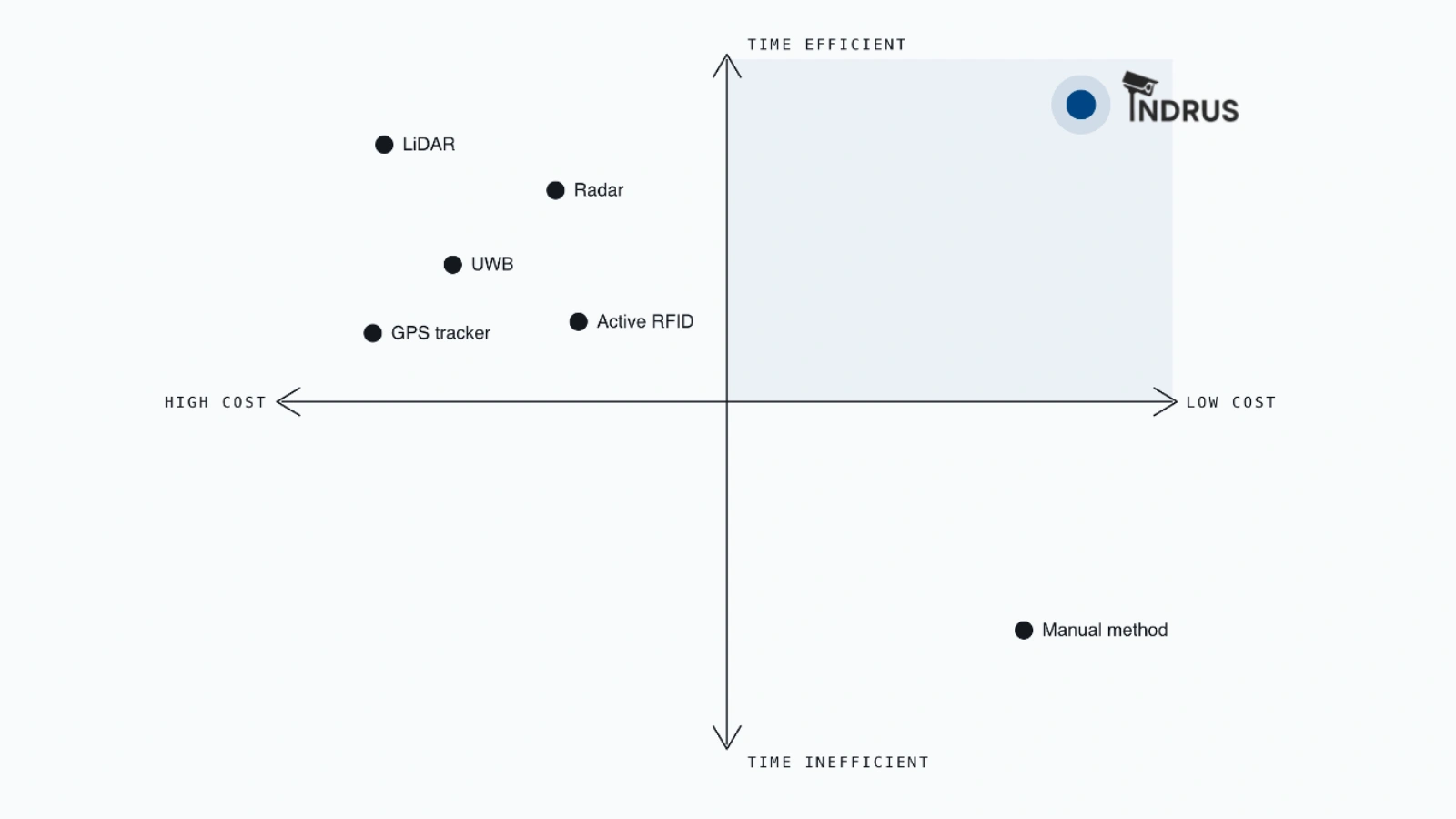
Time and cost comparison of available asset tracking solutions in the market.
Why We're Working on This
For the last 18 months we've spent a lot of time in and around ports and similar large logistics operations, talking to the people who run them day to day, and the people thinking about where they need to be in ten years.
Everyone knows there's problems, but without data it's hard to narrow down the cause and even harder to prioritise, justify investment, or drive change.
We're trying to change that by getting more out of what the port already has... cameras.
Turning Existing Infrastructure into Operational Intelligence
Ports already have cameras everywhere. Security infrastructure that has been installed, maintained, and running for years. The question is whether that footage can be turned into something operationally useful, in real time, without adding hardware or burden to the people on the ground.
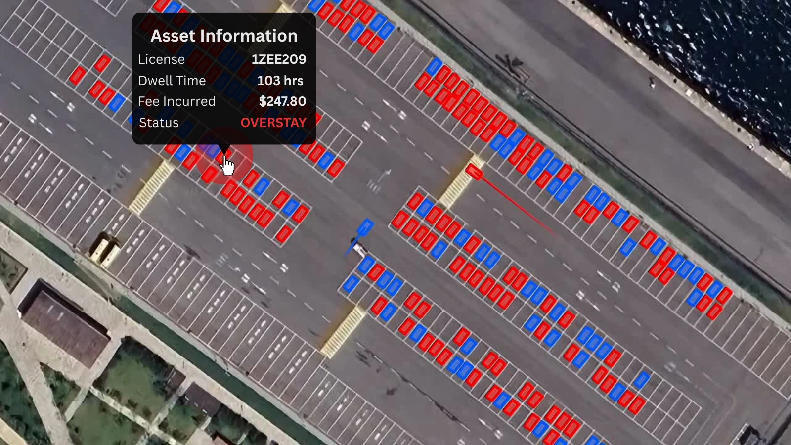
Our system connects to existing CCTV infrastructure and uses geospatial technology to track every vehicle on the berth. The result is a map of the berth with asset positions, updated in real-time, requiring no manual input.
Credit: Signature Security Group
What This Actually Unlocks
Operations teams can see, at a glance, where every asset is, how long it's been there, and what it's done during that time. Disputes that previously involved word of mouth, or required manually reviewing hours of CCTV footage, can be resolved in seconds with a timestamped audit trail.
But the longer-term value is in the data captured.
Operating without reliable landside data often means flying blind when it comes to strategy and planning.
- How efficiently are we using our land?
- How full is the berth?
- What's the average dwell time for vehicles from a particular carrier?
- How efficiently are we discharging?
Getting these answers today is difficult and often just guesswork, which means the decisions built on top of them aren't as good as they could be.
With continuous tracking data, teams can start to see patterns. They can make the case for operational changes with evidence. They can show customers concrete performance metrics. And they can plan incoming vessels against actual available capacity rather than rough estimates.
Starting Without Risk
One of the practical challenges of new technology in port environments is that the stakes are high and the tolerance for disruption is low. We've designed our implementation approach with that in mind.
Before any live system is deployed, we validate the technology against historical footage from the port's own cameras. This means the port can see exactly how the system performs in their specific environment, with their cameras and their vehicles, before any commitment is made. No live integrations, no operational changes.
The data gap on the landside is real, and it's solvable. The infrastructure is already there. It just hasn't been put to work yet.